Lewis & Clark Slept Here, Almost
After leaving the Yellowstone area, it took about thirty minutes for me to acknowledge that I had no idea where we were driving to or which direction we may want to head. Sometimes this “I don’t want a plan thing” can go too far. We have enjoyed the unplanned travel but I needed at least a general direction. Stopping along the road, the Supreme Mistress of Navigation pulled out the Montana road map. Found a few Forest Service campgrounds that could be along the general direction we wanted to go but calls to the nearest Forest Service offices provided no helpful information. Apparently, there are a lot of regional area borders and limited information cross those borders between offices. We finally just put a finger down on the map and decided to wing it. This process worked out well because we ended up on the Pioneer National Byway. Brand new place in Montana for both of us. The Pioneer Mountains contains lush rangeland and another beautiful pocket of history.

This 49-mile byway located on the Beaverhead – Deerlodge National Forest crosses over a 7,800-foot divide and passes through several ecosystems. From a blue-ribbon trout stream to granite peaks topping over 10,000 feet in elevation and then back down to historic rangeland. https://www.visitmt.com/listings/general/scenic-highway/pioneer-mountains-scenic-byway.html


We claimed our campsite along Grasshopper Creek in a Forest Service campground along with several other campers but there was plenty of room separating the sites so it did not feel crowded. A few miles further up the byway we came across Price campground. Price was the nicest Forest Service camp we have ever seen. All the access roads and camping pads were paved and well maintained. Better yet, there is lots of room between the sites with mature pines providing privacy screens. Our exploration of the Pioneer Byway coincided with the peak wildflower bloom. The wet spring produced hundreds of flowers around each campsite.


At the south end of the byway is Bannack State Park which consists of a well-preserved ghost town. The park literature states that Bannack is “preserved rather than exploited”. This contrasts with other “ghost towns” in Montana that have become commercialized. Gold was discovered here in 1862 which lead to a population of around 3000 people. As the gold played out, so did the people. The Princess and I lucked out and missed Bannack Days happening a couple days after our visit. We were told by a ranger that 10,000 visitors show up for the craft displays and demonstration of many pioneer skills necessary to make a living in a late 1800’s gold town. I’m sure the displays would have been interesting, but I enjoyed being able to explore the town while it was a little less hectic. http://bannack.org/bannack-days


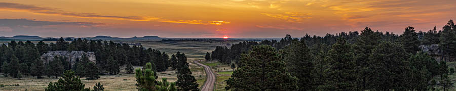
A few miles to the west from Bannack is the Big Hole Pass with panoramic views of the Big Hole valley and the Hamilton ranch which was originally the Carroll Ranch started in 1903 by an Irish immigrant couple. Prior to the Carroll family’s arrival, beef was raised in the valley to sell to migrants on the Oregon Trail that passed nearby. The Carroll ranch grew to over 13,000 acres and was kept in the family until the 1950’s when it was sold and become part of the Hamilton Ranch. I have read that the beef grown on the native grasses in the valley competed well in Eastern markets against the grain fed beef from Kansas. The view from the pass encompasses 400 square miles.

There are two other significant historical events that occurred nearby besides the ranch. One is that the valley plaid host to Lewis and Clark. Lewis described the valley in 1806 as an “excellent road” worn into the countryside over thousands of years. He celebrated his 31st birthday a few miles from the pass where I took a few photos.

About 75 years later, Chief Joseph of the Nez Perce led about 800 men, women and children into the Big Hole Valley as they fled from government troops out of Idaho. They were overtaken and significant battle took place in the Valley. The Nez Perce successfully defended themselves and then kept on their march towards Canada and freedom. As a result of the Nez Perce victory in the Big Hole Valley, the US Army increased the pressure on them and finally capture the band about 40 miles from Canada. The Big Hole National Battlefield https://www.nps.gov/biho/index.htm is dedicated to telling the story of what happened on this site. It is very impressive and is also one stop along the Nez Perce Trail that is part of an Auto Tour. The Auto tour highlights the entire 1500-mile journey. https://nativeamerica.travel/experiences/nez-perce-national-historic-trail


There was so much history and sweeping landscapes with the Pioneer Mountains at the center that I wish the Princess and I would have spent a few more days in these mountains. We have already started talking about trying to fit the full auto tour starting in Oregon next year and ending in Montana, close to the Red Ants Music Festival that we have been attending. Maybe next year.
Dennis and Sherrie